

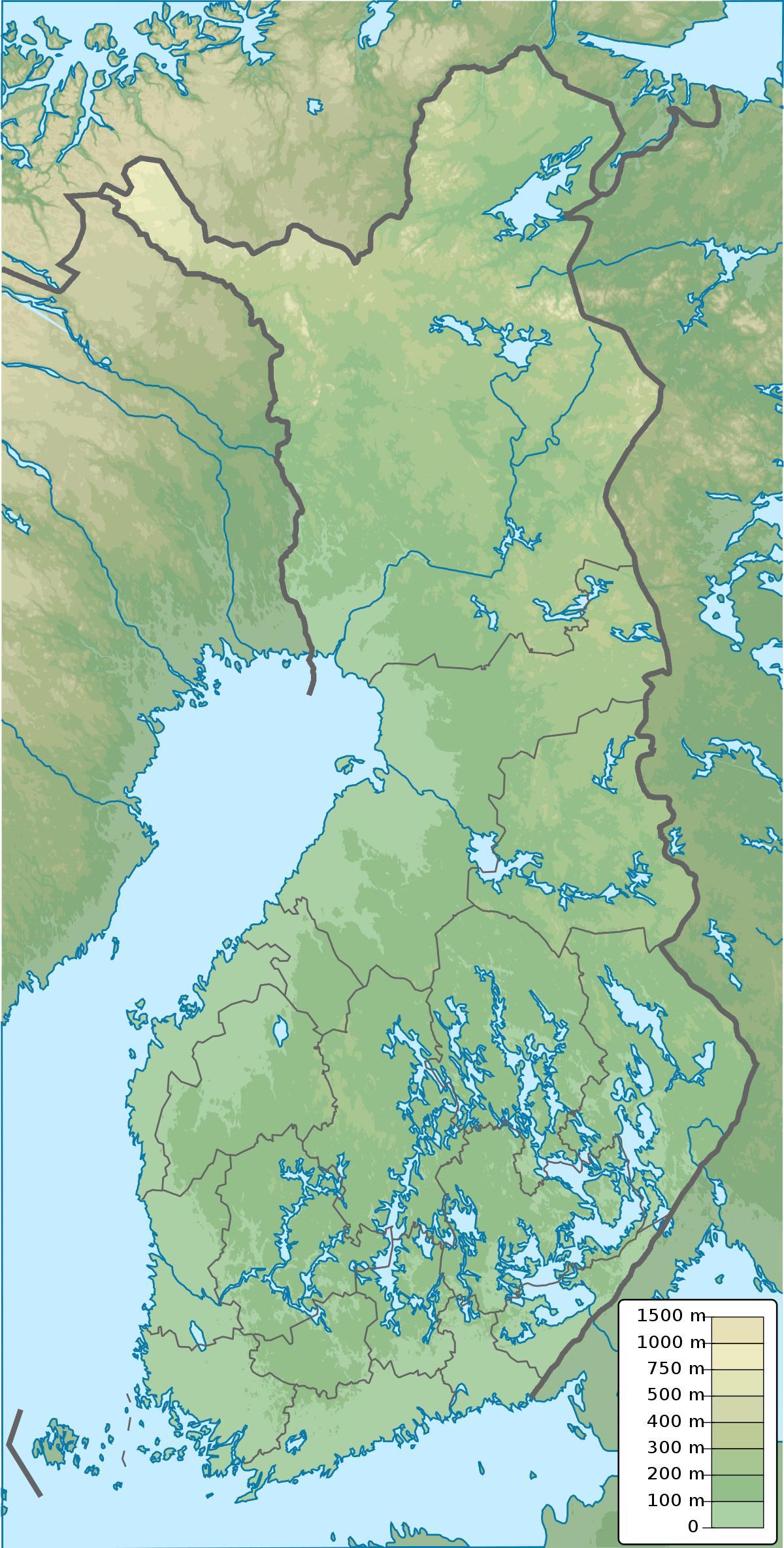
You can find on this page the Finland geographical map to print and to download in PDF. The Finland geographic map presents the topography, elevation, rivers, mountains, climate and physical features of Finland in Northern Europe.
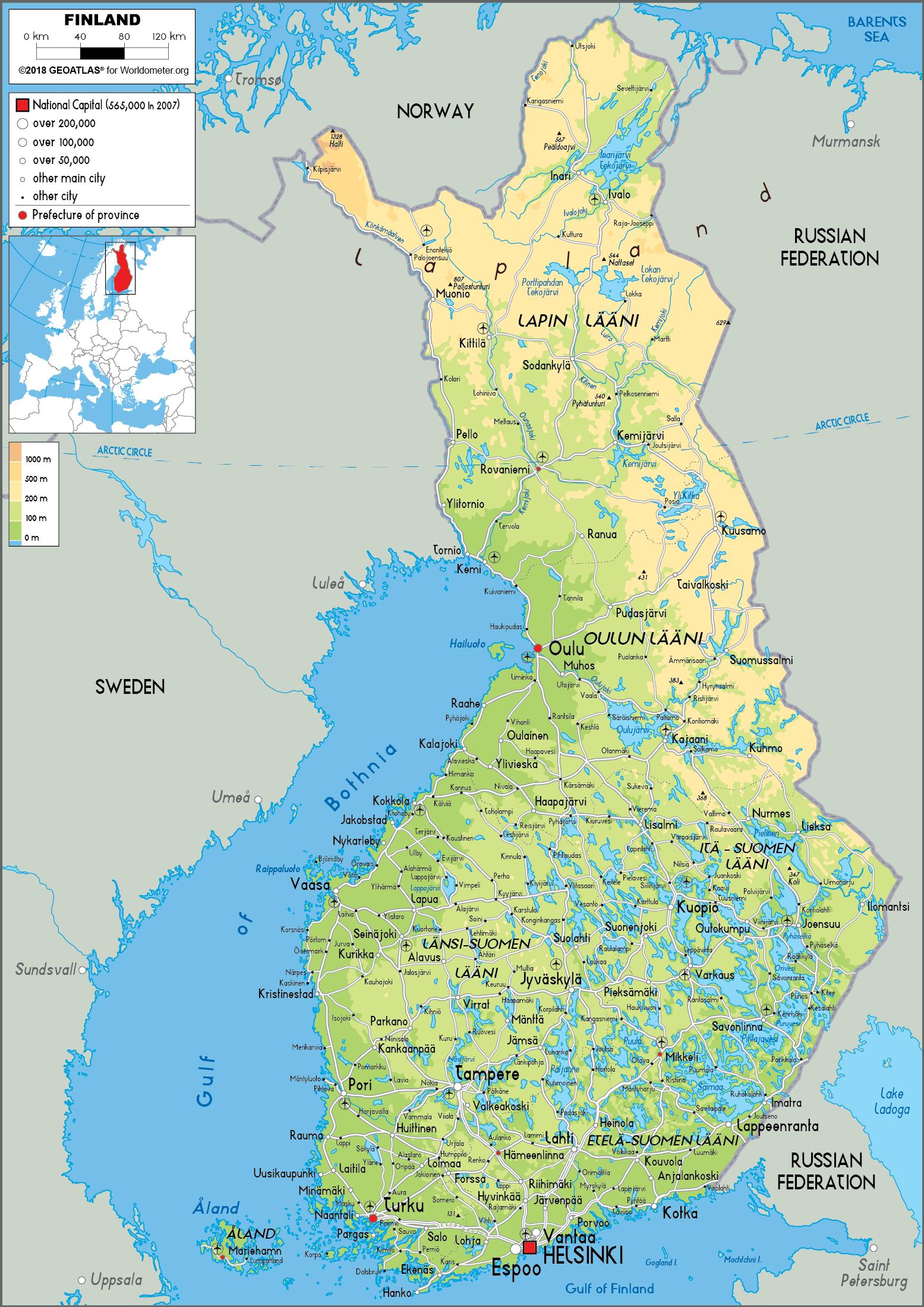
The Finland physical map shows landform and geography of Finland. This geographical map of Finland will allow you to discover physical features of Finland in Northern Europe. The Finland physical map is downloadable in PDF, printable and free.
Many countries of the world can be divided into distinct geographic regions, in each of which some physical characteristic is dominant, almost to the exclusion of others. In Finland, the same physical characteristics are common to each of the four geographic regions into which the country is divided as you can see in Finland physical map. Regional differences in Finland lie, therefore, in subtle combinations of physical qualities. In archipelago Finland, rock and water are dominant. Coastal Finland consists of broad clay plains where agriculture plays a leading role. The interior Finnish lake district supports extensive forests. Upland Finland is covered by Arctic scrub.
Archipelago Finland, consisting of thousands of islands and skerries, extends from the southwestern coast out into the Baltic Sea as its shown in Finland physical map. It includes the strategically significant Åland Islands, positioned at the entrance to the Gulf of Bothnia. After World War I, both Finland and Sweden laid claim to the islands, which are culturally more Swedish than Finnish. For strategic reasons, however, the League of Nations awarded the Åland Islands to Finland in 1921 . A principal reason for this decision was that, during the winter, the islands are physically linked to Finland by the frozen waters of the sea and are thus essential for the country defense. These forest-covered and bare bedrock islands were, and continue to be, formed by the process of uplift following the last glaciation.
The rest of the country is also still emerging from the sea. The weight of the continental glaciers depressed the land over which they moved, and even now, a hundred centuries after their recession, Finland is rising up from this great load through the process of isostatic rebound. In the south and the southwest, this process is occurring slowly, at a rate of twenty-five to thirty centimetres a century. Farther north in the Ostrobothnia area, uplift is more rapid, it amounts to eighty or ninety centimetres a century. The process also means that Finland is growing about seven square kilometres yearly as land emerges from the sea. Coastal Finland consists of broad clay plains extending from the coast inland, for no more than 100 kilometres (62 mi) as its mentioned in Finland physical map. These plains slope southward from the morainic Salpausselkä Ridges in southern Finland. Along the Gulf of Bothnia coast, the plains slope southwest from upland areas. The land of coastal Finland is used for agriculture and dairy farming.
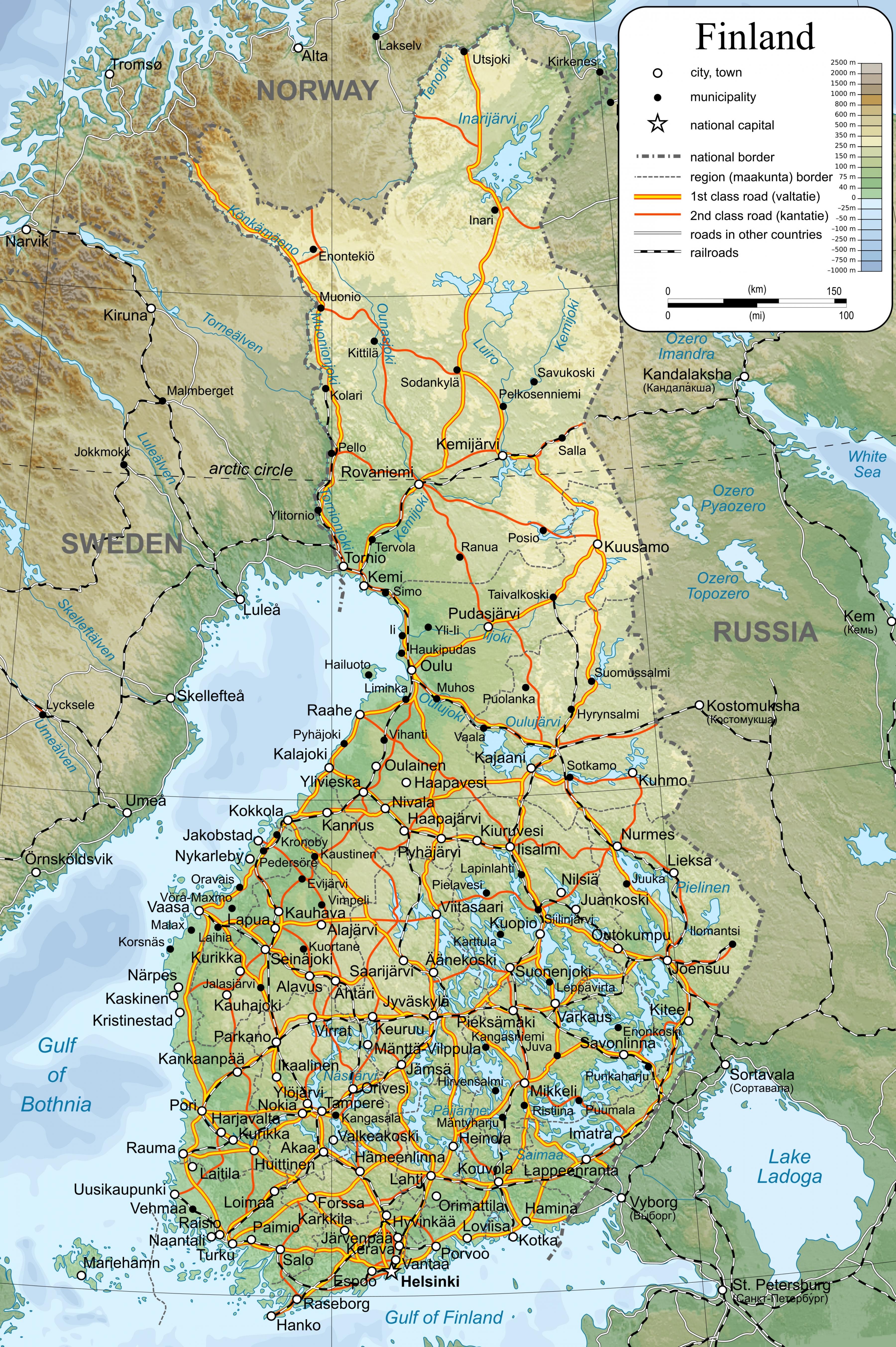
Finland topographic map shows the physical features of Finland. This topographical map of Finland will allow you to discover landforms and geographical of Finland in Northern Europe. The Finland topographic map is downloadable in PDF, printable and free.
Finland is located in Northern Europe along the Baltic Sea, the Gulf of Bothnia, and the Gulf of Finland. It shares borders with Norway, Sweden, and Russia and has a coastline of 776 miles (1,250 km) as you can see in Finland topographic map. The topography of Finland is relatively gentle with low, flat or rolling plains and low hills. The land is also dotted with many lakes—more than 60,000—and the highest point in the country is Haltiatunturi at 4,357 feet (1,328 m) above sea level. Major environmental concerns are: air pollution from manufacturing and power plants contributing to acid rain; water pollution from industrial wastes, agricultural chemicals; habitat loss threatens wildlife populations.
Finland interior lake district is the largest geographic region, and it is perhaps what most foreigners think of when they imagine Finland. The district is bounded to the south by the Salpausselkä Ridges. Behind the ridges extend networks of thousands of lakes separated by hilly forested countryside. This landscape continues to the east and extends into Russia. As a consequence, there is no natural border between the two countries. Because no set definition of what constitutes a lake and no procedures for counting the number of lakes exist, it has been impossible to ascertain exactly how many lakes the region has. There are, however, at least 55,000 lakes that are 200 or more metres wide as its shown in Finland topographic map. The largest is Lake Saimaa, which, with a surface area of more than 4,400 square kilometres (1,700 sq mi), is the fifth largest lake in Europe. The deepest lake has a depth of only 100 metres (330 ft); the depth of the average lake is 7 metres (23 ft). Because they are shallow, these many lakes contain only slightly more water than Finland's annual rainfall. The hilly, forest-covered landscape of the lake plateau is dominated by drumlins and by long sinuous eskers, both glacial remnants.
Southern and western Finland consists of a coastal plain with a severely indented coastline and thousands of small islands stretching out to the Åland Islands. Central Finland is an extensive lake plateau with a majority of the country 60,000 lakes; 24.5% of the area of Mikkelin Province is water. Northern Finland is densely forested upland. The highest elevations are in the Norwegian border areas; northwest of Enontekiö rises Haltia, a mountain 1,328 m (4,357 ft) above sea level as its mentioned in Finland topographic map. Extensive, interconnected lake and river systems provide important natural waterways.

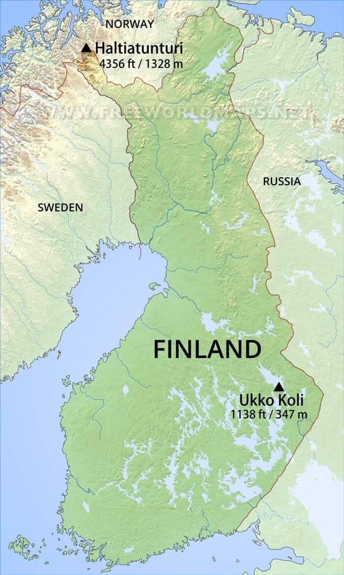
The Finland elevation map shows the different altitudes of Finland. This altitude map of Finland will allow you to know where are the highest and lowest regions of Finland in Northern Europe. The Finland elevation map is downloadable in PDF, printable and free.
Finland reach an elevation of about 1,000 metres (3,300 ft), and they are found in the Kilpisjärvi area of the Scandinavian Keel Ridge as you can see in Finland elevation map. In the southern upland region the hills are undulating, while in the north they are rugged. Much of upland Finland is not mountainous, but consists of bogs. There are, however, at least 55,000 lakes that are 200 or more metres wide. The largest is Lake Saimaa, which, with a surface area of more than 4,400 square kilometres (1,700 sq mi), is the fifth largest lake in Europe. The deepest lake has a depth of only 100 metres (330 ft); the depth of the average lake is 7 metres (23 ft). Because they are shallow, these many lakes contain only slightly more water than Finland's annual rainfall. The hilly, forest-covered landscape of the lake plateau is dominated by drumlins and by long sinuous eskers, both glacial remnants.
Halti (or Finnish: Haltiatunturi, Northern Sami: Háldi, Swedish: Haldefjäll) is the highest fell in Finland, at 1,324 m (4,344 ft) above sea level, and thus the highest elevation point in the country. The Halti fell is located in the municipality of Enontekiö in the province of Lapland at the border between Finland and Norway. The summit of Halti at 1,365 m (4,478 ft) is actually in Norway and it is known as Ráisduattarháldi. Halti was dimensioned and mapped by Finnish Erkki Perä. The highest point in Finland is a spur of Ráisduattarháldi at 1,324 m (4,344 ft) known as Hálditšohkka at the border of Norway as its shown in Finland elevation map. The highest mountain, its peak being in Finland, is Ridnitšohkka, at 1,316 m (4,318 ft). A 50 km (31 mi) trekking path leads from Saana, Kilpisjärvi to Halti.
The terrain of Finland is mostly flat and rolling plains. At 1,316 m (4,318 ft), Mount Halti or “Haltiatunturi” is Finland highest mountain peak as its mentioned in Finland elevation map. This mountain peak shares its border with Norway and is part of the only mountain chain in Finland, the Haltia. Most of Halti is part of Finland. But the highest peak is part of Norway.

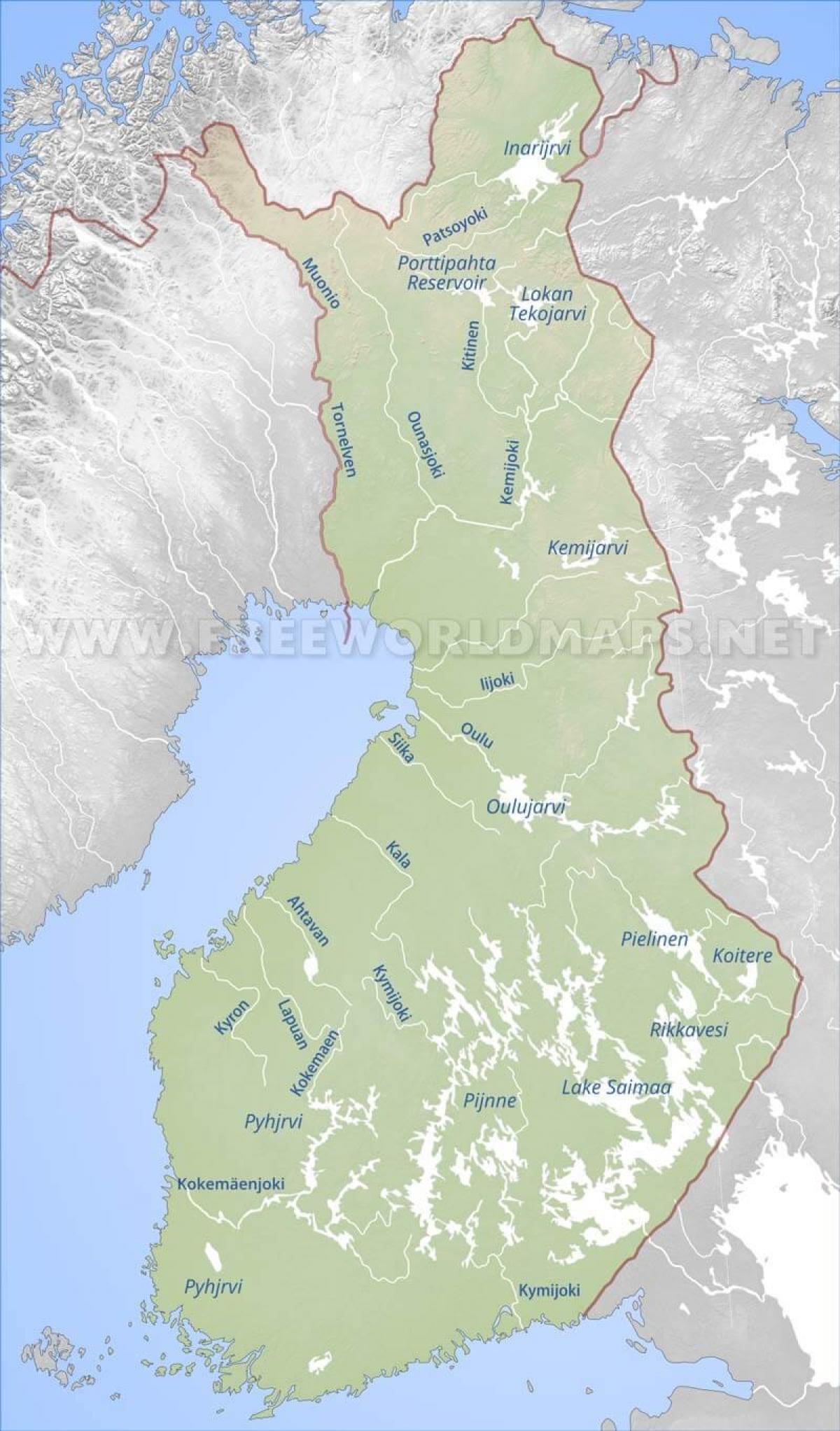
The rivers in Finland map shows the principal rivers with their names of Finland. The rivers map of Finland will allow you to find the main rivers which flow in and through Finland in Northern Europe. The Finland rivers map is downloadable in PDF, printable and free.
Water flows from Finland directly to the Baltic Sea, which is divided here into the Gulf of Bothnia and Gulf of Finland, and the Archipelago Sea between them. Some rivers flow to Russia, ending either to Gulf of Finland or to the White Sea, and a few to the Arctic Ocean trough Russia or Norway. There are a lot of lakes in Finland and so this listing includes also several lakes through which the rivers flow or begin from. Due to the great number of lakes especially in the Finnish Lakeland, where watercources tend to consist of chains of lakes rather than long rivers, some rivers with a large catchment area can also be quite short or there may only be a short rapid between large lakes, like for example Tammerkoski in Tampere. Finland rivers have a number of mouths or drainage points, such as the Gulf of Bothnia, Gulf of Finland, Archipelago Sea, and the Arctic Ocean as you can see in Finland rivers map. However, most rivers and their accompanying tributaries eventually drain into the Gulf of Bothnia. The longest rivers in Finland are the Kemijoki, Tornionjoki, Tenojoki, and Iijoki.
The longest river in Finland is the Kemijoki River, which has a length of about 550 kilometers as its shown in Finland rivers map. The river flows primarily within or along the country's borders, through places such as Kemijärvi and Rovaniemi, before draining into the Gulf of Bothnia. Along its course, the Kemijoki also merges with the Ounasjoki River. Additionally, 15 hydroelectric power plants have been constructed along the river, which produced approximately 34% (about 4.3 TWh) of Finland’s total hydroelectric power in 2003. The Tornionjoki River is the second longest river in Finland, with a length of about 522 kilometers. Also called the Torne or the Tornio, the river starts at Kiruna Municipality, Sweden, flows through Finland, and eventually reaches its mouth at the Gulf of Bothnia. Half of the river's length forms part of the border between Sweden and Finland. The Tornionjoki River has a number of tributaries such as the Njuoraätno, Kåppasjåkka, and Sarvájohka.
With a length of 344 kilometers, the Tenojoki River is the third longest river in Finland as its mentioned . Also called the Tana River, the Tenojoki flows through both Norway and Finland, from its source at Anarjohka-Karasjohka to its mouth at Tanafjorden, Norway. The river has a basin size of about 6,323 square miles and is used for transportation and fishing. In particular, the Tenojoki is renowned for its large quantity of salmon. In 2002, a total of 219,461 pounds of salmon was caught, and each salmon had an average weight of 10 pounds. About 152 kilometers of the river length forms the international border between Norway and Finland. The Iijoki River is the country fourth longest river, with a length of about 330 kilometers. The Iijoki flows within Finland, starting in Iijärvi, a lake near the municipality of Kuusamo, and eventually reaches its mouth at the Gulf of Bothnia. The river has a basin size of about 5,479 square miles, as well as more than 150 rapids along its course. In addition, the Iijoki has a number of tributaries, such as the Livojoki and Siuruanjoki.
The mountains in Finland map shows the principal mountains with their names in Finland. The mountains map of Finland will allow you to find the main mountains ranges and highest mountains of Finland in Northern Europe. The Finland mountains map is downloadable in PDF, printable and free.
Finland is a flat land, but right in the very north of the country lies a magical land of black mountains, waterfalls and narrow trails that will amaze any wilderness enthusiast in the world. Finland is not famous for its mountains, but in the very north-west corner of the country – around 69 degrees north of the equator – lies a wilderness area with several peaks reaching above 1000 metres as you can see in Finland mountains map. It is called the Käsivarsi Wilderness Area, with "käsivarsi" meaning "arm" in Finnish. The name comes from the shape of Finland in that area; if you look at the map it really does look like an arm. In the area, you can find snow spots that never melt, waterfalls, crystal clear lakes and rivers, reindeer herds, arctic animals and rare arctic flora that can survive the freezing 8 months of winter and burst into life during the short summer.
The highest whole mountain (with the mountain peak located in Finland) is called Ridnitšohkka, or Ritničohkka in the Northern Sami language as its shown in Finland mountains map. It is 1317 metres high and around 50 kilometres away from the nearest road. It has the most extensive area of permanent snow in Finland, although in recent years the area has diminished. Next to Ridnitšohkka you will find Halti, or Háldičohkka in Northern Sami. It is the highest point in Finland (1324 metres on the Finnish side), but the actual peak of the mountain is in Norway, approximately 40 metres higher. Reaching Halti requires a hike of several days from the nearest road – and some wilderness experience.
Like its Nordic neighbours, Finland is far more famous for its thousands of lakes and islands, rather than mountains. Halti is the highest point in the country, however, it is not the massif highest mountain peak. The peak is a part of a fell that lies at the border between Finland and Norway far inside the Arctic Circle, and the mountain highest peak is actually situated on the Norwegian side of the border with its peak of 1,365 m (4,478 ft). Ridnitsohkka is the second-highest peak, and the highest mountain located entirely in Finland. It is height is 1,316 m (4,318 ft) and it is located less than a kilometre away from Halti as its mentioned in Finland mountains map. There are a few trekking paths leading to both peaks, however, the remoteness from the nearest villages makes the area very isolated. The five highest peaks in Finland are as follow: Halti – 1,324 m (4,344 ft), Ridnitsohkka – 1,317 m (4,318 ft), Kiedditsohkka – 1,280 m (4,200 ft), Kovddoskaisi – 1,240 m (4,075 ft), Ruvdnaoaivi – 1,239 m (4,065 ft).
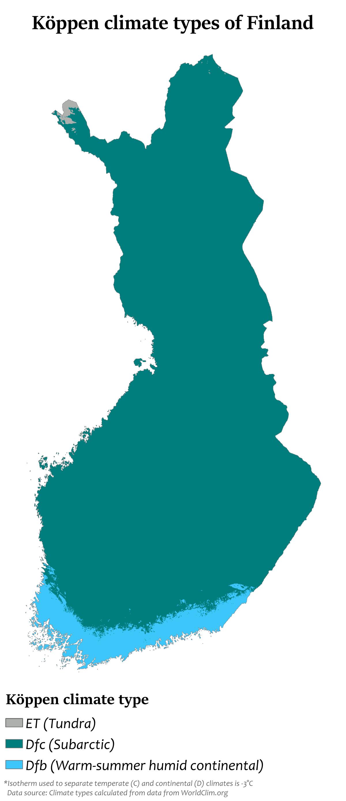
The Finland climate map shows average temperature and climate zones of Finland. This climate map of Finland will allow you to know weather, average precipitation, average sunshine and different climates of Finland in Northern Europe. The Finland climate map is downloadable in PDF, printable and free.
Latitude is the principal influence on Finland climate. Because of Finland northern location, winter is the longest season. Only in the south coast summer is as long as winter. On the average, winter lasts from early December to mid March in the archipelago and the southwestern coast and from early October to early May in Lapland. This means that southern portions of the country are snow-covered about three to four months of the year and the northern, about seven months. The long winter causes about half of the annual 500 to 600 millimetres (19.7 to 23.6 in) of precipitation in the north to fall as snow as you can see in Finland climate map. Precipitation in the south amounts to about 600 to 700 millimetres (23.6 to 27.6 in) annually. Like that of the north, it occurs all through the year, though not so much of it is snow.
The Atlantic Ocean to the west and the Eurasian continent to the east interact to modify the climate of the country. The warm waters of the Gulf Stream and the North Atlantic Drift Current, which warm Norway and Sweden, also warm Finland. Westerly winds bring the warm air currents into the Baltic areas and to the country shores, moderating winter temperatures, especially in the south as its shown in Finland climate map. These winds, because of clouds associated with weather systems accompanying the westerlies, also decrease the amount of sunshine received during the summer. By contrast, the continental high pressure system situated over the Eurasian continent counteracts the maritime influences, occasionally causing severe winters and high temperatures in the summer.
Finland has a predominantly subarctic climate. The majority of the country has a subarctic climate (Köppen climate classification Dfc), with cool summers. The southern coast experiences a humid continental climate (Köppen Dfb), with mild summers as its mentioned in Finland climate map. The highest ever recorded temperature is 37.2 °C (99.0 °F) (Liperi, 29 July 2010). The lowest, −51.5 °C (−60.7 °F) (Kittilä, 28 January 1999). The annual middle temperature is relatively high in the southwestern part of the country (5.0 °C/41.0 °F to 7.5 °C/45.5 °F), with quite mild winters and warm summers, and low in the northeastern part of Lapland (0 °C/32 °F to −4 °C/25 °F). Compared to the Scandinavian countries, Finland has a colder climate because of the proximity to Russia.