

You can find on this page the Finland region map to print and to download in PDF. The Finland political map presents states, regions, provinces and surrounding areas of Finland in Northern Europe.

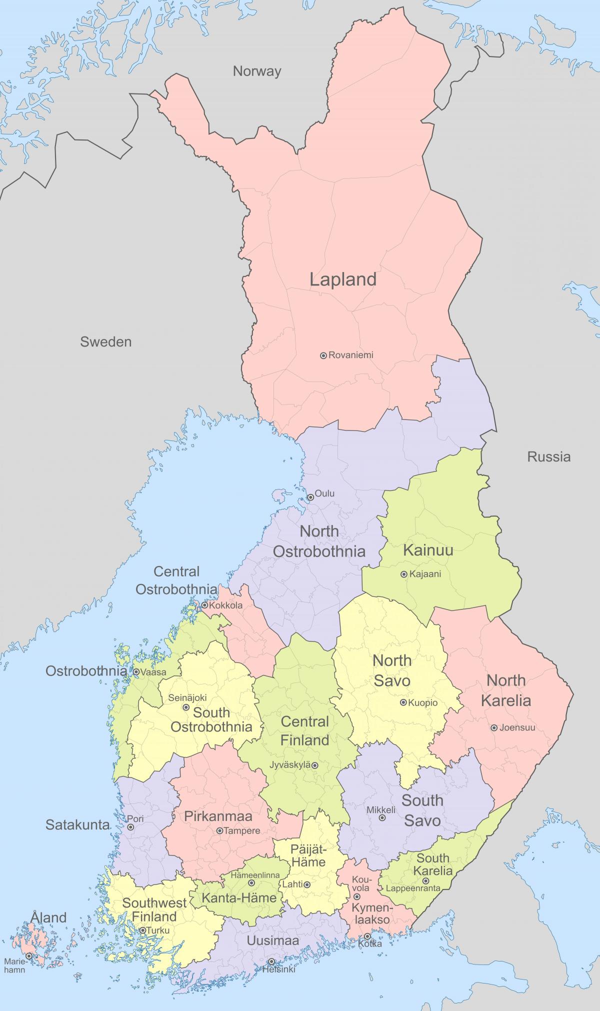
The Finland regions map shows surrounding areas and provinces of Finland. This administrative map of Finland will allow you to know regions of Finland in Northern Europe. The Finland regions map is downloadable in PDF, printable and free.
Finland regions are governed by regional councils, which serve as forums of cooperation for the municipalities of a region. The main tasks of the regions are regional planning and development of enterprise and education. In addition, the public health services are usually organized on the basis of regions. Currently, the only region where a popular election is held for the council is Kainuu as its mentioned in Finland regions map. Other regional councils are elected by municipal councils, each municipality sending representatives in proportion to its population. In addition to inter-municipal cooperation, which is the responsibility of regional councils, each region has a state Employment and Economic Development Centre, which is responsible for the local administration of labour, agriculture, fisheries, forestry and entrepreneurial affairs. The Finnish Defence Forces regional offices are responsible for the regional defence preparations and for the administration of conscription within the region.
Finland regions represent dialectal, cultural and economic variations better than the former provinces, which were purely administrative divisions of the central government. Historically, regions are divisions of historical provinces of Finland, areas which represent dialects and culture more accurately. Six Regional State Administrative Agencies were created by the state of Finland in 2010, each of them responsible for one of the regions called alue in Finnish and region in Swedish; in addition, Åland was designated a seventh region as youcan see in Finland regions map. These take over some of the tasks of the earlier Provinces of Finland (the läänis), which were abolished. These are not to be confused with maakuntas, although both are translate as "region".
There are three principal regions in Finland as its shown in Finland regions map: a coastal plain, an interior lake district, and an interior tract of higher land that rises to the fells (tunturi) of Lapland. The coastal plain comprises a narrow tract in the south, sloping from Salpausselkä to the Gulf of Finland; the plains in the southwestern part of the country; and the broad western coastal lowlands of the region of Pohjanmaa (Ostrobothnia) facing the Gulf of Bothnia. The coastal region has the most extensive stretches of farmland; this region also is the site of the longest continuous settlement and has the largest number of urban centres. Associated with it are the offshore islands, which are most numerous in the Turun archipelago off Turku on the southwest coast. Farther to the north in the Gulf of Bothnia another group of islands lies off Vaasa (Vasa).

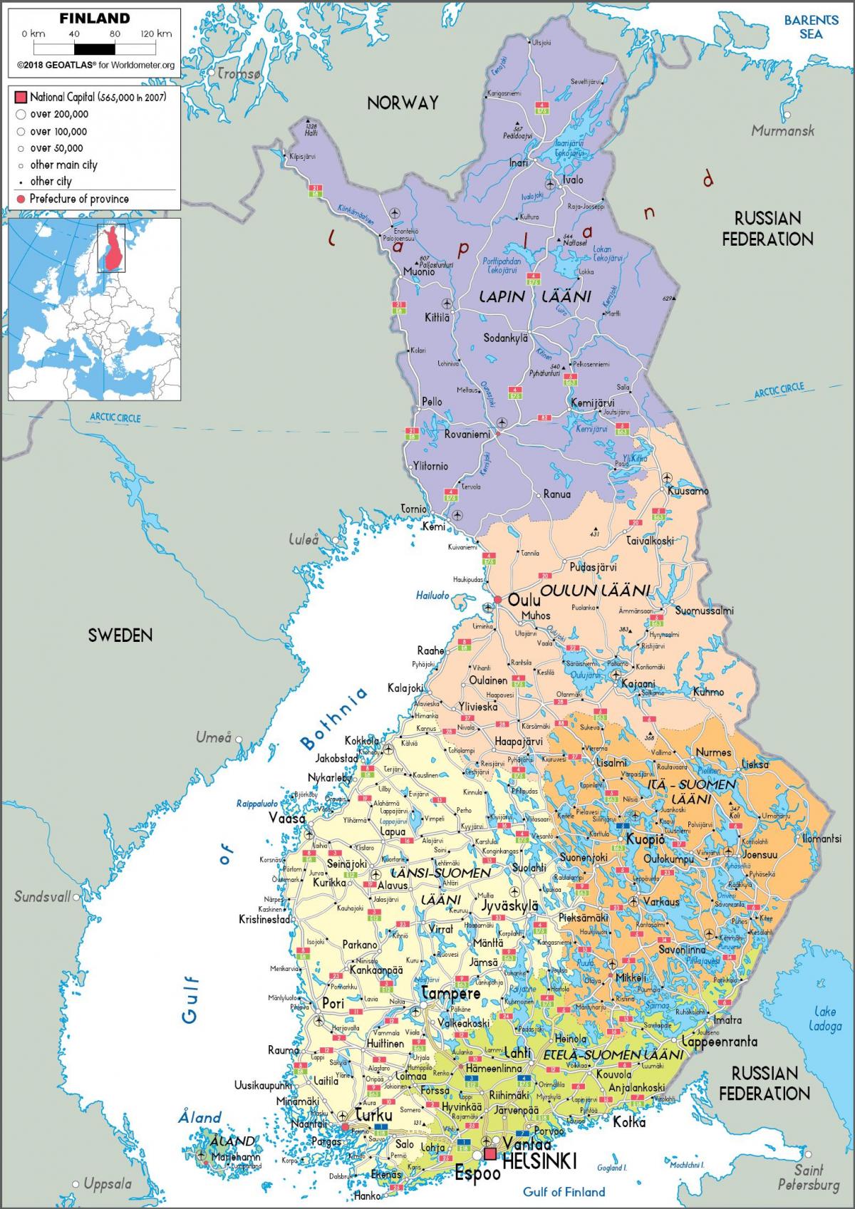
The Finland political map shows regions and provinces of Finland. This administrative map of Finland will allow you to show regions, administrative borders and cities of Finland in Northern Europe. The Finland political map is downloadable in PDF, printable and free.
Politics of Finland takes place in a framework of a parliamentary representative democratic republic and of a multi-party system. The President of Finland is the head of state, leads the foreign policy, and is the Commander-in-chief of the Defense Forces as its mentioned in Finland political map. The Prime Minister of Finland is the head of government; executive power is exercised by the government. Legislative power is vested in the Parliament of Finland, and the government has limited rights to amend or extend legislation. The president has the power of veto over parliamentary decisions although it can be overrun by the parliament. Finns enjoy individual and political freedoms, and suffrage is universal at 18; Finnish women became the first in the world to have unrestricted rights both to vote and to stand for parliament.
The labor agreements of Finland pose significant political questions. Bargaining is highly centralized and often the government participates to coordinate fiscal policy. Finland has universal validity of collective labour agreements and often, but not always, the trade unions, employers and the government reach a Comprehensive Income Policy Agreement. Significant trade unions are SAK, STTK, AKAVA and EK as you can see in Finland political map. Finland has a parliamentary system, even if the President of Finland is formally responsible for foreign policy. Most executive power lies in the cabinet (the Finnish Council of State) headed by the prime minister. Responsibility for forming the cabinet out of several political parties and negotiating its platform is granted to the leader of the party gaining largest support in the elections for the parliament.
Finland proportional representation system encourages a multitude of political parties and has resulted in many coalition-cabinets as its shown in Finland political map. Formerly the life expectancy of the coalition governments has been short, but since about 1980 the trend has been that the same coalition rules for the whole period between elections. Finland elects on national level a head of state—the president—and a legislature. The president is elected for a six year term by the people. The Parliament (Finnish: eduskunta, Swedish: riksdag) has 200 members, elected for a four year term by proportional representation in multi-seat constituencies. Finland has a multi-party system, with three strong parties, in which no one party often has a chance of gaining power alone, and parties must work with each other to form coalition governments.

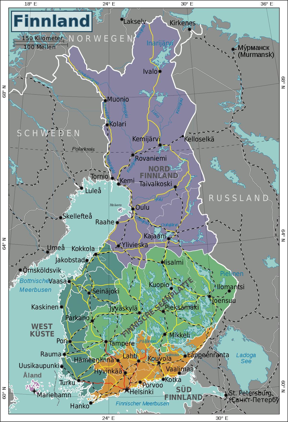
The Finland states map shows all departments and regions of Finland. States map of Finland will allow you to know areas and cities of Finland in Finland. The Finland states map is downloadable in PDF, printable and free.
The state of Finland comprised six states (Finnish: läänit, Swedish: län) between the years 1997 and 2009 as its mentioned in Finland states map. The provincial authority was part of the central government executive branch, not directly elected. The system was created in 1634, and its makeup was changed drastically in 1997, when the number of the states was reduced from twelve to six. This effectively made them purely administrative units, as linguistic and cultural boundaries did not follow the borders of the states.
Finland states were abolished altogether on January 1, 2010. State administration has two local hierarchies, ely-keskus and aluehallintovirasto. Six Regional State Administrative Agencies (aluehallintovirasto, regionförvaltningsverk, abbr. avi) – in addition to the Government of Åland – are primarily responsible for law enforcement: Etelä-Suomi, Itä-Suomi, Lounais-Suomi, Länsi- ja Sisä-Suomi, Pohjois-Suomi, Lappi as you can see in Finland states map. Among these, Lounais-Suomi and Länsi- ja Sisä-Suomi cover the old state of Länsi-Suomi, and the old state of Oulu was renamed as Pohjois-Suomi; other old provincial boundaries remain much the same in the new disposition. There are 15 elinkeino-, liikenne- ja ympäristökeskus, which are responsible for other state administration: employment, road and transport infrastructure, and environmental monitoring.
In 1634, administratives states were formed in Sweden, and therefore in Finland, which was a part of Sweden until 1809 (see Finland states map). Five of the states covered what is now Finland; some of these also covered parts of what are now Russia. The exact division of the country into states has fluctuated over time. The boundaries of the old provinces partly survives in telephone area codes and electoral districts. The exception is Helsinki: there is a telephone numbering area that comprises Greater Helsinki (code 09), while only the city of Helsinki proper comprises the electoral district of Helsinki. The rest of Greater Helsinki belonging to the Uusimaa electoral district. States governed only state offices, such as the police. Most services, such as healthcare and maintenance of local streets, were and remain the responsibility of municipalities of Finland. Many municipalities are too small for a hospital and some other services, so they cooperate in municipality groups, e.g. health care districts, using borders that vary depending on the type of service. Often Swedish-language municipalities cooperate even if they do not share a border.